
The proposed ordinance amendment that would allow the use of outside fill in the floodplains of Macon County is heading to a public hearing and possible vote. Critics says the county is rushing a process without local expert input. The public hearing is set for July 9 during the regular Board of Commissioners meeting.
The proposed ordinance change would allow a landowner to use outside fill in up to 25% of a property’s “flood fringe” area without needing a no-impact study; a study would be required for the use of fill above that amount. Currently, no fill is allowed in the floodplain for county properties. “Flood fringe” is the area outside of the floodway (rivers, creeks, streams) subject to flooding during heavy rain.
Public hearings for two additional ordinance changes also will be held July 9. One change would remove a ban on RV parks from the watershed protection ordinance and the other would change the mandate for a soil erosion and sedimentation control plan from half an acre to a full acre. There has been no public version of what exactly those two changes could entail and neither have been discussed publicly after May 14.
Commissioner Josh Young introduced the changes at the March 7 Planning Board meeting. In late May, a four-person subcommittee of two commissioners and two planning board members met once to draft and confirm that the 25% outside fill proposal met the minimum state and FEMA guidelines. The creation of a subcommittee was affirmed by consensus at the May 14 commissioners meeting, but the committee members were not identified at that time.
The suggested ordinance changes were introduced four months ago. This contrasts with the extensive process two decades ago when Macon County first developed the ordinances following a deadly debris flow and multiple life-saving flooding incidents in Macon County’s waterways.
In three public meetings held in May and June, around 25 people spoke either against any outside fill changes or were in favor of taking a long look at any changes. Two people spoke in favor of making changes and decried the current ordinance. Many of these speakers spoke at multiple meetings.
Young has spearheaded the possible outside fill revisions. Young told the Planning Board he wanted the county’s outside fill and minimum soil erosion and sediment control plan requirements to match the state requirements. Young felt like Macon County going above the state requirements was an “extra burden” on Macon County citizens. He told the story of a farmer south of Franklin along Georgia Road who wanted to build a new access point but couldn’t due to the outside fill ban in the floodplain.
According to County Planner Caleb Gibson the county has had 15 floodplain permits filed since January 2023.
“Some of the questions they ask are how close can we build to the stream, and how high they will have to build it,” Gibson stated.
Public opposition
Most public comments have been against the proposed ordinance change. At the May 2 Planning Board meeting, 23 of the 24 public speakers spoke about making no changes, strengthening watershed protections, and/or being careful and taking their time in reviewing the ordinance.
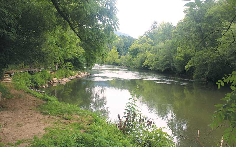
The consensus of those opposed to the use of fill is that increased outside fill in a floodplain will result in more water in the floodways, leading to eroded streambanks, faster flood waters and more silt in the county’s waterways. Silted-up floodways and eroded streambanks can slow the normal flow of water after the flood water recedes, leading to hotter water temperatures. Both these results could impact the wildlife that use the river.
Critics of outside fill in the floodplain also point to the 2004 Peeks Creek disaster that led to implementing a ban on outside fill in the floodplain. In September 2004, a nighttime debris flow caused by a landslide on the mountain above the Peeks Creek community killed five people and destroyed 15 houses.
Kenneth McCaskill of North Carolina Farm Bureau said his entire board and the state board endorsed the current ordinance against outside fill in the floodplain. Jordan Smith, executive director of Mainspring Conservation Trust, said all board members, past board members, “staffers and investors” were against allowing outside fill in the floodplain. Former planning board members and planning board members from Jackson County spoke in support of the current ordinance.
The only pro-ordinance change speaker on May 2 was Franklin Town Council Member David Culpepper, who said the current ordinance “turns landowners into criminals” if they want to add a culvert or access road.
At that May 2 meeting, the Planning Board voted to table discussion on the floodplain ordinance. The board has not met since.
The May 14 Board of Commissioners meeting had nine speakers about the floodplain, all of whom spoke on May 2, and eight were against it.
One local business owner who hasn’t spoken directly to any board but opposes any changes is Jerry Anselmo, owner of Great Smokey Mountain Fish Camp and Safaris, situated on 20 acres bordering the Little Tennessee River. Anselmo discovered Macon County in 1987 and turned a former World War II mining center into a recreation hot spot.
“This is where I’m gonna die at, right here,” Anselmo said in his store.
Anselmo spoke of his conservation work, including preserving the bald eagles. On a nice day, Anselmo said he sits on his porch and watches bald eagles pluck fish from the river.
“I get [people] from all over the world. And they come here, and of course, they come for the river and everything, but they spend money, they help support our little town,” Anselmo said.
Anselmo is against allowing outside fill in the county’s floodplain, wanting to keep the Little Tennessee River like it is.
“It’s one of the best smallmouth [fishing] rivers in the world,” Anselmo said, noting the washout for the river would be terrible and impact the houses already along the river.
Subcommittee meeting
On May 14, Young and Lewis Penland, a former planning board member and contractor, brokered the subcommittee idea. The commissioners reached a consensus on forming a subcommittee. No members were publicly approved. Former Macon County Planning Director Joe Allen, and a four-member committee of Young, Commissioner Danny Antoine, and Planning Board members Barry Breeden and Larry Lackey met on May 29. The meeting was not publicly advertised or described until afterward. (The Franklin Press has requested minutes of that meeting.)
Allen, who was the Macon County Planner until 2024, resigned as Macon County’s plan reviewer effective June 28. Allen declined to say why he resigned other than that it was for personal reasons.
At the May 29 meeting, the subcommittee talked to the state floodplain mapping office, which OK’ed the possible changes and said they were within FEMA guidelines. The subcommittee consulted no other experts.
During the June 11 county commissioners meeting when the draft of the ordinance amendment was introduced, 13 people spoke, with 12 against any changes. Allen called the proposed 25% outside fill allowance “middle-of-the-road changes.”
Bill McLarney, a Little Tennessee River landowner and aquatic biologist, has spoken to the Planning Board and commissioners against allowing outside fill in the floodplain. He said the committee only having one meeting and not calling any of the recommended experts lacks the transparency needed for a process like that.
McLarney said the issue isn’t one landowner filling 25% of his floodplain with outside fill, but several doing so and compounding the volume of water put into the waterway.
The origins of the floodplain ordinance
McClarney said banning outside fill in the floodplain after the 2004 Peeks Creek disaster took years and input from multiple experts and residents.
Stacy Guffey, currently the Franklin vice mayor, was the Macon County planner at the time. Guffey said multiple hurricanes in 2004, including Hurricane Ivan, led to the Peeks Creek disaster. At the time, the county had no floodplain restrictions.
“Dozens of homes were damaged or destroyed along the Little Tennessee River and Cullasaja River,” Guffey said.
Afterward, a mix of federal and state money created updated landslide hazard maps and the commissioners directed the county planning board to review and revise the floodplain ordinance.
“We met for months doing the revisions,” Guffey said. “At the time, we had an active watershed council. The planning board felt because of their expertise, as they had hydrologists, engineers and folks like that, [the planning board] wanted [the changes] to go through them as well.”
Guffey said several people spoke at these meetings about how their property had been flooded and how it was more severe than in the past.
“They referenced people upstream or directly across [the river] who had filled or put obstructions in their floodplain,” Guffey said. “People [who were flood victims] were concerned about their property rights being violated, and the flood was fresh in everyone’s mind.”
Guffey said the ban on outside fill in the floodplain “felt like common sense.”
Not allowing RVs in floodplains came because of “several” RVs ending up in the river and people trapped due to the floods carrying them away.
“It put them and the emergency workers in danger,” Guffey said. “Our aim was to mitigate those dangers.”
After the ordinance passed, Guffey explained that those with homes in the floodplain beforehand were allowed to rebuild but had to build higher above the base elevation for safety.
Guffey says while the ordinance isn’t perfect, it felt like the right thing to do after the 2004 floods.
“It’s one thing to have one parcel up to 25% [fill in the floodplain]. Cumulatively, if you have 25 parcels [that fill up to 25% of the floodplain], then you got an impact on the floodplain and flood levels,” Guffey said. “I would trust that our leaders would take their time to look at the impacts really carefully.”