
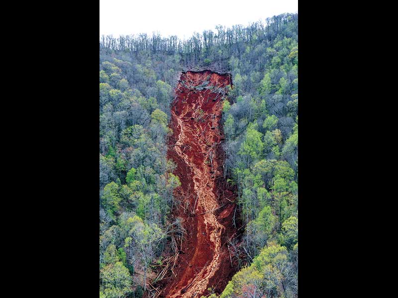
The N.C. Geological Survey sent teams to study the debris flows that occurred following torrential rains on April 12 and has reported the findings to Macon County Emergency Services.
Field surveys were conducted at four locations that were impacted by debris flow: Valley View Trail and Chavis Road; Dobson Mountain; Turkey Pen Road; and Trimont Mountain Road and Doghobble Drive.
The assessment, which was requested by Macon EMS, found no immediate threat to “life safety,” but reported that residual debris could continue to affect the areas and that the margins of the slopes are unsafe.
“The main intent of this preliminary study was to see if there were any other imminent life-safety hazards that we need to be concerned about,” said Warren Cabe, the county’s emergency services director.
There were no immediate threats identified, but the areas bear watching.
“There were concerns about residual debris that will come down when we have other significant rain events,” Cabe said. “Typically we have strong spring storms, so there’s probably going to be more runoff and debris.”
In the first four months of 2020, Macon County saw about a foot more rain than the average. The Coweeta Hydrological Lab in Otto recorded a total of 39.81 inches of rain in the four-month period from January through April, according to Patsy Clinton, hydrological technician. Average rainfall for the period is 27.07 inches.
Totals were 9.52 inches in January (average 6.87); 13.35 inches in February (average 6.94); 6.97 in March (average 7.33); and 9.97 in April (average 5.98).
Dobson Mountain
In terms of sheer volume, the debris flow on Dobson Mountain was the largest of the slides, racing about 4,000 feet down the mountain with a torrent of soil, trees and rocks that scoured about 16.8 acres.
Cabe said the Dobson Mountain slide carried as much or more material than the 2004 Peeks Creek slide that killed five people. That slide was about two miles in length.
“This one was shorter, which means it was deeper, down to the bedrock,” he said.
The slide did not damage any homes, but flow deposits piled up behind C.J.’s Recycling on Maxwell Home Road.
The Dobson flow occurred along a tributary that feeds into Cartoogechaye Creek, upstream of a water intake for the Town of Franklin.
“We’ve asked the NRSC (Natural Resources Conservation Services) to take a look at that to see if there’s anything they can do for us trying to determine if it’s going to cause some issue with that water intake,” Cabe said.
Cabe stressed that there is no immediate threat to the town’s water supply.
“It’s a cause for concern but not an imminent hazard,” he said. “It might just be a long-term issue that needs addressing.”
Valley View Trail and Chavis Road
“The debris flows at these locations damaged roads [and] private properties, and severely damaged at least two residences,” the NCGS reported.
Although the assessment did not identify any immediate threats to other residences at the flow site, that “in no way implies that other slope failures in these areas would not occur in the future. Because the slopes are over-steepened in the debris flow source areas, the margins of these slopes are unsafe,” the NCGS reported.
Turkey Pen and Enchanted Mountain
The NCGS identified four debris flows in the Turkey Pen and Enchanted Mountain areas of the Potts Branch watershed on the southeast-facing slopes of Dobson Mountain. The assessment identified no imminent threats to any homes.
“The largest debris flow damaged the residential buildings at 504 Turkey Pen Road and caused substantial damage to Turkey Pen Road,” the NCGS reported.
Three other flows were identified in the Enchanted Mountain area that damaged the road and a residential well head.
Trimont Mountain Road and Doghobble Drive
“Road-related failures at both locations mobilized into rapidly moving debris flows that impacted properties outside of the road corridors,” according to the NCGS assessment, which determined that the roads at the slide sites are “general unsafe” FOR vehicular traffic.
The report recommended replacing the culvert at Trimont Mountain Road with a larger-diameter one.
“The debris flows stripped vegetation and surface soil along their paths,” the assessment found. “Revegetation of the track areas for erosion control is advisable to reduce further erosion and stream sedimentation.”